
Houston History Mystery #3: Strange formations in east Houston
Maybe this isn't so difficult to solve, but for weeks, members of the Houston Architecture Info Forum have been trying to figure out some odd-looking ovals located off Clinton Drive.
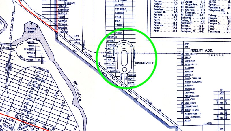
The above image is from a WWII-era map of Houston. Note the three circular shapes set inside a pill-shaped circle. Does anyone know what this once was?
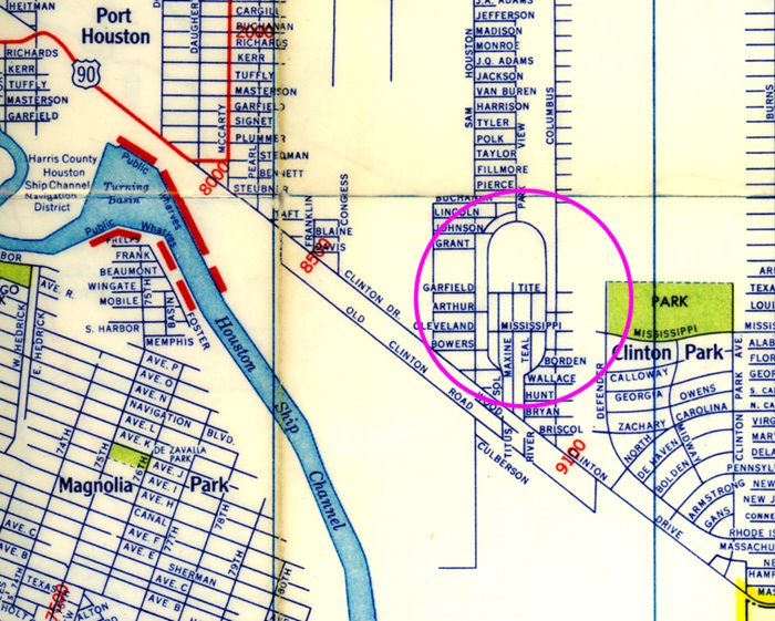
The second image is from a 1950s map of Houston. As you can see, Tite and Mississippi street cut through the area. Part of the shape remains, but it appears that the original landmark no longer exists.
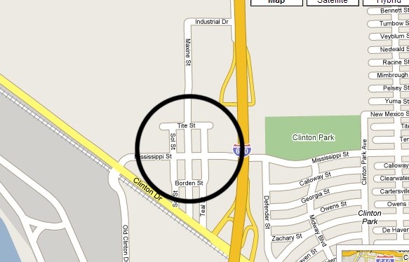
The last image is from Google maps. The landmark doesn't appear to exist at all anymore.
Some have speculated that it could have been a park though no one is completely sure. Can you solve this mystery?
Meanwhile, our previous Houston History Mysteries remain unsolved:
The case of the missing murals
The case of the missing flagstaff
Labels: Houston History Mystery
posted by J.R.G. @ 1:54 AM
7 comments
![]()
![]()

7 Comments:
It's a promenade, possibly also for bikes...Parkview?
http://www.houstonarchitecture.info/haif/index.php?s=7e3d6e464a1408ce88655cbe193da63a&showtopic=4512&pid=113391&st=100&#entry113391
I'm not sure. As for missing items, isn't the statue that used to be on top of the old court house missing as well?
Nope. Some say a statue existed atop the old courthouse, but the Chronicle reported in 2004 that it was never erected. Modifications were made to the original plans, and it didn't include a statue. A new one will go up once renovations are complete, though.
I am not sure what this is, BUT there was a Sherman tank test track in that area. The site would have been owned by a company named Reed Roller Bit. I know this because my Father used to work there. It may be that the original circular shapes evolves to an oval in the earl fifty's, late forty's.
That would make sense. No one has floated that possibility yet, but it certainly seems plausible.
The "formations" in question are not animate objects but are the cartographer's rendition on the map of how a proposed subdivision would be laid out. The main circle in the center was going to be a cluster of homes circled by street blocks. The two outer circles were to be smaller clusters of homes. If you look at subsequent maps of the area, you will see how the developing subdivision progressed. But it appears that the subdivision did not entirely develop as proposed on the original map.
Those formations are just what they look like...a Horseracing Track.
Post a Comment
<< Home